
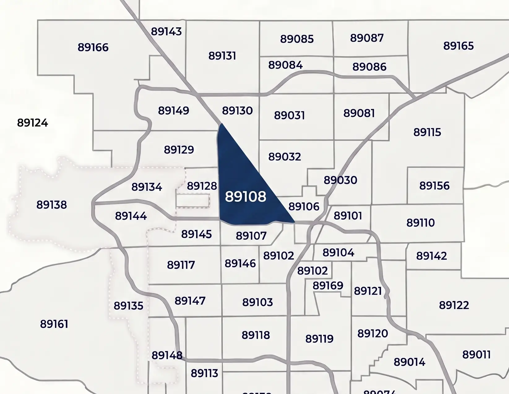
Located in the heart of the Northwest Valley, the 89108 ZIP code is defined by its distinct triangular shape, bordered by the US-95 “Curve,” Rancho Drive, and Rainbow Boulevard. This area serves as a vital residential corridor for commuters, sitting directly across from the North Las Vegas Airport (VGT) and just north of the College of Southern Nevada (CSN) Charleston Campus.
Unlike the master-planned communities further west, 89108 is a stronghold for No-HOA housing, featuring established mid-century tract homes and large ranch-style lots that offer a unique “Old Vegas” feel with modern proximity to the Las Vegas Strip and Downtown. Whether you are researching local school zones or commuting via the Rancho/95 Interchange, this guide provides the essential demographics and geographic context for 89108.
89108 ZIP Code Quick Facts
| Metric | 2026 Data Point |
| ZIP Code | 89108 |
| Primary City | Las Vegas, NV |
| County | Clark County |
| Total Population | ~72,814 |
| Median Household Income | $59,449 |
| Median Home Value | ~$389,900 |
| Residential Character | Established / Non-HOA |
Where is the 89108 ZIP Code Located?
The 89108 ZIP code is located in the Northwest Las Vegas Valley within Clark County, Nevada. To locals and real estate professionals, it is widely recognized for its distinct triangular shape, which is formed by three major geographic borders:
- The Western Border: Defined by Rainbow Boulevard.
- The Eastern Border: Defined by Rancho Drive, which runs diagonally southeast to northwest.
- The Southern/Western “Curve”: Created by the US-95 Freeway, which makes a sharp 90-degree turn to form two sides of the ZIP code’s boundary.
This strategic location makes 89108 one of the most accessible “commuter” ZIP codes in the valley. It sits just a few miles from Downtown Las Vegas and is directly adjacent to the North Las Vegas Airport (VGT) and the CSN Charleston Campus, offering a 10–15 minute drive to the Las Vegas Strip.
89108 Schools and Education
Families in the 89108 ZIP code are served by the Clark County School District (CCSD). This sector of the Northwest Valley is particularly notable for hosting one of the nation’s premier magnet programs alongside established neighborhood schools.
Key Schools in the 89108 Area:
- Advanced Technologies Academy (A-Tech): A consistent top-ranked magnet high school in Nevada, known for its computer science and engineering programs.
- Somerset Academy – Lone Mountain: A highly-sought-after K-8 charter school option located on the western edge of the ZIP code.
- Cheyenne High School: The primary public high school anchor for the northern portion of the 89108 area.
- J. Harold Brinley Middle School: A central middle school serving the community’s heart.
- Berkeley L. Bunker Elementary School: A long-standing public elementary school rooted in the neighborhood.
- Mountain View Christian School: A well-known private school anchor that has served local families for decades.
89108 Housing Market and the “No-HOA” Factor
One of the primary reasons 89108 remains a top target for Las Vegas homebuyers in 2026 is the prevalence of Non-HOA neighborhoods. Unlike the master-planned communities found further west in Summerlin, a significant portion of 89108 features established residential tracts developed between the 1960s and 1980s.
Neighborhoods such as Charleston Heights are famous for offering homeowners larger-than-average lots and the freedom of no monthly HOA fees or restrictive covenants. The median home value in 89108 currently sits around $350,000 to $360,000, making it one of the more affordable entry points for single-family homes in the valley.
The architectural variety here is a major draw, ranging from classic mid-century modern tract homes to sprawling ranch-style properties. This mix of affordability, autonomy, and mature landscaping makes 89108 a standout ZIP code for buyers who prioritize space and independence over the standardized look of newer suburban developments.
Interactive Map of the 89108 ZIP Code
To explore the specific streets and boundaries of 89108, use the interactive map below. This view provides a detailed look at the major intersections, including Rancho and Lake Mead, as well as the proximity of the North Las Vegas Airport to the residential neighborhoods within the ZIP.
Nearby ZIP Codes & Las Vegas Directory
Because of its central location in the Northwest Las Vegas Valley, 89108 shares boundaries with several key residential and commercial sectors. You can explore these neighboring areas below or return to our Las Vegas ZIP Codes Directory for a full overview of the valley.
- 89032 (Northeast): Located just across the North Las Vegas border, primarily serving the North Las Vegas community.
- 89106 (East): Bordering the eastern side of Rancho Drive, this area includes the Historic Westside and leads into Downtown Las Vegas.
- 89107 (South): Located directly south of the US-95, home to the Springs Preserve and the Meadows Mall.
- 89128 (West): The neighboring sector to the west, which includes the Desert Shores and Summerlin-adjacent communities.
- 89130 (North): Extending north toward Lone Mountain, providing a more suburban residential feel.
Frequently Asked Questions about 89108 ZIP code
What city and county is ZIP code 89108 in?
ZIP code 89108 is located entirely within the city limits of Las Vegas, Nevada, in Clark County. While it borders North Las Vegas along Rancho Drive, it is officially a Las Vegas ZIP code serving the Northwest portion of the valley.
Is the 89108 area mainly residential?
Yes. 89108 is a densely populated residential area characterized by established neighborhoods and single-family homes. It is a popular “commuter” ZIP code due to its direct access to the US-95 and its proximity to the North Las Vegas Airport and Downtown Las Vegas.
What are the boundaries of 89108?
The area is geographically defined by its “Triangle” shape, bounded by Rainbow Boulevard to the west, Rancho Drive to the east, and the US-95 freeway to the south and west.
Does 89108 have Homeowners Associations (HOAs)?
A significant portion of 89108 consists of Non-HOA neighborhoods. This is one of the primary draws for homebuyers in the area, offering more freedom and lower monthly costs compared to the newer master-planned developments in the Las Vegas valley.
What schools are in the 89108 area?
89108 is home to several notable educational institutions, including the top-ranked Advanced Technologies Academy (A-Tech) and Somerset Academy – Lone Mountain, alongside a variety of established Clark County School District (CCSD) public campuses.