
Las Vegas includes many neighborhoods, districts, master-planned communities and residential areas across the city and the wider Las Vegas Valley. Well-known areas include Downtown Las Vegas, Summerlin, Centennial Hills, Desert Shores, Rancho Oakey and Huntridge, along with many smaller neighborhoods and subdivisions.
There is no single accepted count of Las Vegas neighborhoods because different sources define them in different ways. Some lists include only neighborhoods within the incorporated City of Las Vegas. Others also include master-planned communities and unincorporated places such as Paradise, Spring Valley and Enterprise, which are commonly associated with Las Vegas but lie outside the city limits.
Las Vegas Neighborhoods Map
Las Vegas neighborhood geography includes several different types of places and boundaries. The map below separates the incorporated City of Las Vegas from the wider Las Vegas Valley. It also shows how official planning areas, neighborhoods, districts, master-planned communities and surrounding unincorporated communities relate to one another.
The City of Las Vegas panel uses the city's 16 community planning areas as its primary geographic framework. Selected neighborhoods and districts are also shown where reliable location or boundary information is available. The Las Vegas Valley panel provides broader context for Clark County community areas such as Paradise, Spring Valley, Enterprise, Sunrise Manor, Winchester, Whitney and Summerlin South, along with nearby incorporated cities.
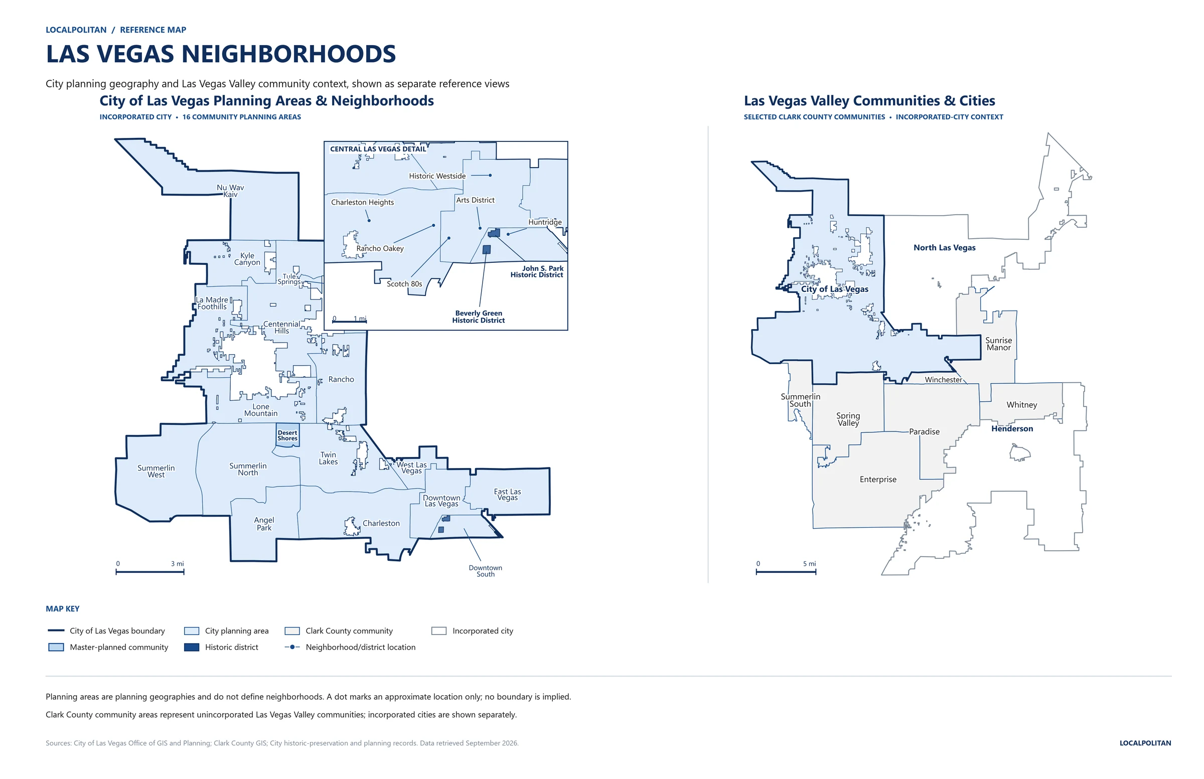
Map note: Localpolitan created this reference map using City of Las Vegas and Clark County GIS and planning data, along with City historic-preservation records. Planning areas are planning geographies and do not define individual neighborhoods. Locally recognized neighborhoods without a verified boundary are shown by approximate location rather than with an exact perimeter.
A printable version of the map is also available. Download the Printable Las Vegas Neighborhoods Map (PDF) to save or print for reference.
Reuse This Las Vegas Neighborhoods Map
Websites, publications, educators, businesses and organizations may reuse the Localpolitan Las Vegas Neighborhoods Map with attribution. Please credit Localpolitan and link to the original Las Vegas Neighborhoods page when the map is published online. The map should not be altered to remove Localpolitan branding or presented as another publisher's original cartography.
Embed This Map
Copy the HTML below to embed the Localpolitan Las Vegas Neighborhoods Map on your website. Please keep the attribution and link intact.
Las Vegas Neighborhoods at a Glance
Las Vegas includes traditional neighborhoods, districts, master-planned communities and larger planning areas. The wider Las Vegas Valley also includes several unincorporated communities that are commonly associated with Las Vegas even though they are outside the incorporated city.
The table below highlights several well-known areas and shows how they are classified geographically.
| Place | Geographic Type | General Area | Jurisdiction |
|---|---|---|---|
| Downtown Las Vegas | City planning area and downtown area | Central Las Vegas | City of Las Vegas |
| Arts District | District | Central Las Vegas | City of Las Vegas |
| Rancho Oakey | Neighborhood | Central-west Las Vegas | City of Las Vegas |
| Huntridge | Historic residential neighborhood | Central Las Vegas | City of Las Vegas |
| Historic Westside | Historic and cultural neighborhood | Central-west Las Vegas | City of Las Vegas |
| Charleston Heights | Residential neighborhood area | West-central Las Vegas | City of Las Vegas |
| Desert Shores | Master-planned community | Northwest Las Vegas | City of Las Vegas |
| Summerlin | Master-planned community spanning multiple jurisdictions | Western Las Vegas Valley | City of Las Vegas and unincorporated Clark County |
| Paradise | Unincorporated community | Central Las Vegas Valley | Clark County |
| Spring Valley | Unincorporated community | West-central Las Vegas Valley | Clark County |
| Enterprise | Unincorporated community | Southwest Las Vegas Valley | Clark County |
| Sunrise Manor | Unincorporated community | East and northeast Las Vegas Valley | Clark County |
| Winchester | Unincorporated community | Central-east Las Vegas Valley | Clark County |
| Whitney | Unincorporated community | Southeast Las Vegas Valley | Clark County |
| Summerlin South | Unincorporated Clark County community | Western Las Vegas Valley | Clark County |
These classifications help explain why Las Vegas neighborhood lists can look very different from one source to another. Some sources count only traditional neighborhoods, while others also include districts, subdivisions, master-planned communities and unincorporated areas elsewhere in the Las Vegas Valley.
How Las Vegas Neighborhoods Are Defined
There is no single official system that defines every Las Vegas neighborhood. Different sources may count traditional neighborhoods, districts, subdivisions, master-planned communities, planning areas or unincorporated communities. As a result, two Las Vegas neighborhood lists can include very different places and still be describing the same general region.
Why Las Vegas Neighborhood Lists Differ
Neighborhood counts vary because the term neighborhood is used broadly. A local resident may use it for a familiar residential area, while a real estate website may also include subdivisions, master-planned communities or nearby unincorporated areas. Government agencies use additional geographic systems for planning, administration and statistical purposes.
These systems are not interchangeable. A City planning area can contain multiple neighborhoods, while a master-planned community may contain numerous subdivisions. An unincorporated community can also be commonly associated with Las Vegas without being part of the incorporated city.
Neighborhoods and Districts
Traditional neighborhoods are generally recognized residential or mixed-use areas with a local identity. Their boundaries may be well documented, loosely understood or different depending on the source.
Districts usually have a more specific purpose or identity. Downtown districts, historic districts and cultural districts can overlap with broader neighborhoods, but their boundaries should not automatically be treated as neighborhood boundaries.
Master-Planned Communities
Master-planned communities are larger developments designed under an organized land-use plan. They may contain multiple villages, subdivisions or smaller residential areas.
Summerlin is one of the best-known examples in the Las Vegas Valley. Its geography spans more than one jurisdiction, which is why Summerlin should not be treated as a single traditional neighborhood with one simple municipal boundary. Desert Shores is another master-planned community within the City of Las Vegas.
Unincorporated Communities and CDPs
Much of the Las Vegas Valley lies outside incorporated city limits. Paradise, Spring Valley, Enterprise, Sunrise Manor, Winchester and Whitney are examples of unincorporated Clark County communities that are often grouped into broader discussions of Las Vegas neighborhoods.
Some unincorporated communities are also represented by Census-designated places, or CDPs. CDPs are statistical areas used by the U.S. Census Bureau and should not be confused with incorporated cities or locally defined neighborhood boundaries. County community boundaries and Census CDP boundaries can also differ even when they use the same place name.
City of Las Vegas Planning Areas
The City of Las Vegas uses 16 community planning areas as part of its geographic planning framework. These areas organize the incorporated city for planning purposes, but they are not a complete list of Las Vegas neighborhoods. A single planning area can contain multiple neighborhoods, districts, subdivisions and master-planned communities.
| Planning Area | Planning Area |
|---|---|
| Angel Park | La Madre Foothills |
| Centennial Hills | Lone Mountain |
| Charleston | Nu Wav Kaiv |
| Downtown Las Vegas | Rancho |
| Downtown South | Summerlin North |
| East Las Vegas | Summerlin West |
| Kyle Canyon | Tule Springs |
| Twin Lakes | West Las Vegas |
The City GIS uses West Las Vegas as the planning-area name. Historic Westside is a separate cultural and historic place name and should not be treated as another name or boundary for the West Las Vegas planning area.
Major Neighborhoods in Las Vegas
Las Vegas has many named neighborhoods, districts and master-planned communities within the incorporated city. Some have well-documented boundaries, while others are recognized more by local identity and general location. The areas below are several of the better-known places that help define different parts of Las Vegas.
Downtown Las Vegas
Downtown Las Vegas is the historic and civic core of the city. It includes the area around Fremont Street, the government center and several residential and commercial districts near the original city center.
Downtown is also one of the City of Las Vegas community planning areas. Smaller districts and neighborhoods within and around downtown have their own identities, so the broader downtown area should not be treated as one traditional residential neighborhood.
Arts District
The 18b Las Vegas Arts District is a cultural and commercial district south of Downtown Las Vegas, centered around Main Street and Charleston Boulevard. The district includes galleries, vintage and antique shops, restaurants, breweries and coffee shops. Much of its commercial activity is concentrated along Main Street, Casino Center Boulevard and Third Street.
The City of Las Vegas identifies the Arts District as a distinct downtown master-plan district and maintains mapped district boundaries for planning purposes. Brewery Row along Main Street is one of its better-known commercial concentrations.
Rancho Oakey
Rancho Oakey is an established residential neighborhood west of Downtown Las Vegas, centered broadly around Rancho Drive and Oakey Boulevard. Alta Drive and Charleston Boulevard are also major east-west corridors through the surrounding area. Nearby destinations include the Springs Preserve and the Las Vegas Medical District.
The City of Las Vegas recognizes a Rancho Oakey Neighborhood Association, but that association boundary should not automatically be treated as the definitive boundary of the entire neighborhood. Rancho Oakey also should not be confused with Rancho, which is the name of a much larger City community planning area.
Huntridge
Huntridge is a historic residential neighborhood southeast of Downtown Las Vegas. Much of the area commonly associated with Huntridge lies between Charleston Boulevard and Oakey Boulevard, with older residential streets extending around 10th Street, Maryland Parkway and nearby blocks.
The neighborhood developed through several early residential tracts rather than as one formally defined subdivision. City historic-resource surveys document portions of Huntridge, but those survey areas do not establish an official boundary for the entire neighborhood. Localpolitan therefore treats Huntridge as a recognized neighborhood location rather than a fixed geographic polygon.
Historic Westside
Historic Westside is one of Las Vegas's best-known historic and cultural neighborhoods. It is located northwest of Downtown Las Vegas and has played an important role in the city's African American history and community development.
Historic Westside is separate from West Las Vegas, which is the official name of one of the City's 16 community planning areas. The two terms should not be treated as interchangeable geographic boundaries.
Charleston Heights
Charleston Heights is a long-established residential area in west-central Las Vegas, around the Charleston Boulevard corridor and nearby neighborhoods between Rainbow Boulevard and Decatur Boulevard. The broader area lies near the Springs Preserve, with US 95 to the north and Oakey Boulevard farther south.
Current City planning documents do not treat Charleston Heights as one single neighborhood. The Charleston Area Plan identifies Charleston Heights East, Charleston Heights West and Charleston Heights South as distinct neighborhoods. A separate City historic-resource survey used a broader Charleston Heights study area for preservation research, so those survey boundaries should not be treated as one definitive modern neighborhood perimeter.
Desert Shores
Desert Shores is a master-planned community in northwest Las Vegas. Unlike many informal neighborhood names, Desert Shores has a documented master-plan boundary within the incorporated City of Las Vegas.
The community is part of the larger northwest side of the city and is geographically distinct from the broader planning areas and neighborhood names that surround it.
Summerlin
Summerlin is a large master-planned community along the western side of the Las Vegas Valley. Portions of Summerlin are inside the City of Las Vegas, including areas represented by the Summerlin North and Summerlin West community planning areas.
The broader Summerlin development extends beyond the incorporated city, however. Summerlin South is an unincorporated Clark County community, so Summerlin should not be treated as one neighborhood contained entirely within Las Vegas city limits.
Las Vegas Neighborhoods by Area
Las Vegas neighborhoods can also be grouped by their general location within the city. These regional groupings are practical geographic references rather than official neighborhood boundaries, since individual neighborhoods and communities may overlap broader areas or use different local definitions.
Central Las Vegas
Central Las Vegas contains many of the city's older and best-known neighborhoods and districts. This area includes Downtown Las Vegas, the Arts District, Huntridge, Rancho Oakey, Scotch 80s, Historic Westside, Beverly Green and John S. Park.
The central city contains a mix of historic residential areas, downtown districts and established neighborhoods that developed around the original urban core.
Western Las Vegas and Summerlin
The western side of Las Vegas includes established residential areas such as Charleston Heights and portions of the larger Summerlin master-planned community. Summerlin North and Summerlin West are also official City planning areas within this part of Las Vegas.
Summerlin extends beyond the incorporated city, so the broader community should not be treated as entirely within Las Vegas city limits.
Northwest Las Vegas
Northwest Las Vegas includes Desert Shores and areas commonly associated with Centennial Hills, Lone Mountain and Tule Springs. This part of the city contains a mix of established master-planned communities and newer development extending toward the northern and western edges of Las Vegas.
East Las Vegas
East Las Vegas includes residential areas east of the downtown core and forms one of the City's official community planning areas. The incorporated city becomes more geographically fragmented toward the eastern side of the valley.
Several communities commonly associated with east or southeast Las Vegas, including Sunrise Manor and Whitney, are actually outside the incorporated City of Las Vegas.
Las Vegas Valley Communities Outside the City Limits
Several major communities in the Las Vegas Valley are commonly described as Las Vegas neighborhoods even though they are outside the incorporated City of Las Vegas. These areas are unincorporated parts of Clark County and are governed by the county rather than the City of Las Vegas.
Many addresses in these communities still use Las Vegas, NV as the mailing city. A Las Vegas mailing address, however, does not necessarily mean a property is within Las Vegas city limits.
Paradise
Paradise is an unincorporated community in the central Las Vegas Valley. It includes a large share of the Las Vegas Strip, Harry Reid International Airport, the University of Nevada, Las Vegas, and surrounding residential and commercial areas along major corridors such as Paradise Road, Tropicana Avenue and Flamingo Road.
Paradise is one of the clearest examples of the difference between Las Vegas as a commonly used place name and the incorporated City of Las Vegas. Many destinations internationally associated with Las Vegas are actually within unincorporated Clark County.
Spring Valley
Spring Valley is an unincorporated community west and southwest of central Las Vegas. It extends roughly from Sahara Avenue south toward Pebble Road and from Decatur Boulevard west to Hualapai Way. Major corridors include Rainbow Boulevard, Durango Drive, Flamingo Road and Fort Apache Road, while Desert Breeze Park and Community Center provide a prominent local geographic anchor.
Spring Valley is a large, heavily developed part of the west valley rather than a neighborhood within the City of Las Vegas. Its Las Vegas mailing addresses and continuous urban development with surrounding areas help explain why the distinction is often overlooked.
Enterprise
Enterprise is a large unincorporated community in the southwestern Las Vegas Valley, south of Spring Valley and west of Henderson. Major corridors include Blue Diamond Road, Las Vegas Boulevard South, Rainbow Boulevard and the 215 Beltway. Mountain's Edge is a major master-planned community within Enterprise, while the eastern side of the area includes substantial employment and commercial development near Harry Reid International Airport.
Enterprise has grown into one of the largest population centers in the valley, with a mix of newer suburban development, established large-lot residential areas and expanding commercial corridors. Despite its size and Las Vegas mailing addresses, it remains under Clark County jurisdiction.
Sunrise Manor
Sunrise Manor is an unincorporated community across the eastern and northeastern Las Vegas Valley. Major corridors include Nellis Boulevard, Charleston Boulevard, Lake Mead Boulevard and the Boulder Highway/Fremont Street corridor. Development extends east toward Frenchman and Sunrise mountains, while the community also wraps around portions of Nellis Air Force Base.
Sunrise Manor contains extensive residential and commercial development and is fully integrated into the Las Vegas urban area. Its location against the eastern mountains gives it a distinct geographic setting even though it remains outside the incorporated City of Las Vegas.
Winchester
Winchester is an unincorporated community near the center of the Las Vegas Valley, immediately east of parts of the Las Vegas Strip. It includes the Las Vegas Convention Center area and extends through established residential and commercial areas near Paradise Road, Desert Inn Road, Sahara Avenue and Maryland Parkway.
Its Strip-adjacent location makes Winchester particularly easy to mistake for a Las Vegas city neighborhood. Winchester is instead governed by Clark County and forms part of the broader unincorporated urban core surrounding the City of Las Vegas.
Whitney
Whitney is an unincorporated community in the eastern and southeastern Las Vegas Valley near Boulder Highway, East Tropicana Avenue and Russell Road. Much of its developed area lies west of the Las Vegas Wash and Clark County Wetlands Park, with Henderson bordering the community to the south.
Whitney includes established residential neighborhoods, commercial development along Boulder Highway and Tropicana Avenue, and areas that transition toward the open-space and industrial geography surrounding the Las Vegas Wash. It remains part of unincorporated Clark County rather than the City of Las Vegas.
Summerlin South
Summerlin South is an unincorporated Clark County community and planning area on the western edge of the Las Vegas Valley. It extends south from Charleston Boulevard along the western side of the valley, with Hualapai Way forming much of its eastern edge and federally managed land near Red Rock Canyon defining much of its western setting. The 215 Beltway passes through the area, and Downtown Summerlin serves as its major commercial center.
Summerlin South is part of the broader Summerlin master-planned community, but Summerlin crosses local jurisdictions. Summerlin North and Summerlin West are City of Las Vegas planning areas, while Summerlin South is unincorporated Clark County. The broader Summerlin area therefore should not be treated as one neighborhood contained entirely within Las Vegas city limits.
Las Vegas Neighborhoods vs. Nearby Cities
Not every place commonly associated with Las Vegas is a neighborhood. Henderson and North Las Vegas are separate incorporated cities with their own municipal governments and city limits. Both are part of the developed Las Vegas Valley, which can make the boundaries between communities feel less obvious on the ground.
Boulder City is also a separate incorporated city in Clark County. It lies southeast of the main Las Vegas urban area near Lake Mead and Hoover Dam, giving it a more geographically distinct setting than Henderson or North Las Vegas.
| Place | Geographic Status | Relationship to Las Vegas |
|---|---|---|
| Las Vegas | Incorporated city | Contains its own neighborhoods, districts and planning areas |
| North Las Vegas | Separate incorporated city | Adjoins Las Vegas on the northern side of the urban area |
| Henderson | Separate incorporated city | Occupies much of the southeastern Las Vegas Valley |
| Boulder City | Separate incorporated city | Southeast of the main urban area near Lake Mead and Hoover Dam |
City boundaries matter because they determine which municipal government has jurisdiction over planning, zoning and many local services. Being part of the Las Vegas metropolitan area does not make Henderson, North Las Vegas or Boulder City a neighborhood of the City of Las Vegas.
Las Vegas Neighborhoods and ZIP Codes
Las Vegas neighborhoods do not correspond neatly to individual ZIP Codes. Neighborhoods and communities are local geographic places, while ZIP Codes are postal delivery areas created for mail routing. Their boundaries can overlap, and one neighborhood may extend across several ZIP Codes.
The same problem works in reverse. A single ZIP Code can include more than one neighborhood, subdivision or community area. This means a ZIP Code should not be used by itself to determine whether an address is inside a particular Las Vegas neighborhood or even within the incorporated City of Las Vegas.
Large communities such as Summerlin, Spring Valley and Paradise span multiple ZIP Codes. Smaller neighborhoods may occupy only part of a ZIP Code. Mailing addresses can add another layer of confusion because many locations outside Las Vegas city limits still use Las Vegas, NV as the postal city. The Las Vegas ZIP Codes map shows how postal areas extend across the City of Las Vegas and surrounding communities in the wider valley.
Frequently Asked Questions About Las Vegas Neighborhoods
How many neighborhoods are in Las Vegas?
There is no single official count of Las Vegas neighborhoods. Different sources may include traditional neighborhoods, districts, subdivisions, master-planned communities, City planning areas and nearby unincorporated communities. The total therefore depends on which geographic categories are being counted.
Is Summerlin a neighborhood of Las Vegas?
Summerlin is better described as a large master-planned community rather than a single neighborhood. Parts of Summerlin are within the City of Las Vegas, including the Summerlin North and Summerlin West planning areas. Summerlin South is an unincorporated Clark County community outside the city limits.
Are Paradise and Spring Valley neighborhoods of Las Vegas?
No. Paradise and Spring Valley are unincorporated Clark County communities rather than neighborhoods within the incorporated City of Las Vegas. Both are commonly associated with Las Vegas because they are part of the same urban area and many addresses use Las Vegas as the mailing city.
Is Henderson a neighborhood of Las Vegas?
No. Henderson is a separate incorporated city with its own government and municipal boundaries. It is part of the wider Las Vegas Valley and metropolitan area, but it is not a neighborhood of the City of Las Vegas.
Are Las Vegas planning areas the same as neighborhoods?
No. The City of Las Vegas uses 16 community planning areas as part of its planning framework. A planning area can contain multiple neighborhoods, districts, subdivisions and master-planned communities.
Do Las Vegas neighborhood boundaries match ZIP Code boundaries?
No. Neighborhoods and ZIP Codes use different geographic systems. A neighborhood may cross several ZIP Codes, while one ZIP Code can include multiple neighborhoods or communities.
Explore More Las Vegas Resources
Continue exploring Las Vegas and the surrounding valley with these Localpolitan reference pages:
- Las Vegas — City overview and geographic reference
- Las Vegas ZIP Codes — ZIP Code map, complete list and regional breakdowns
- What Cities Are in the Las Vegas Valley? — Incorporated cities and major communities across the valley
- Cities in Clark County, Nevada — Incorporated cities and major unincorporated places in Clark County
- Unincorporated Places in Nevada — How Nevada’s unincorporated communities differ from incorporated cities